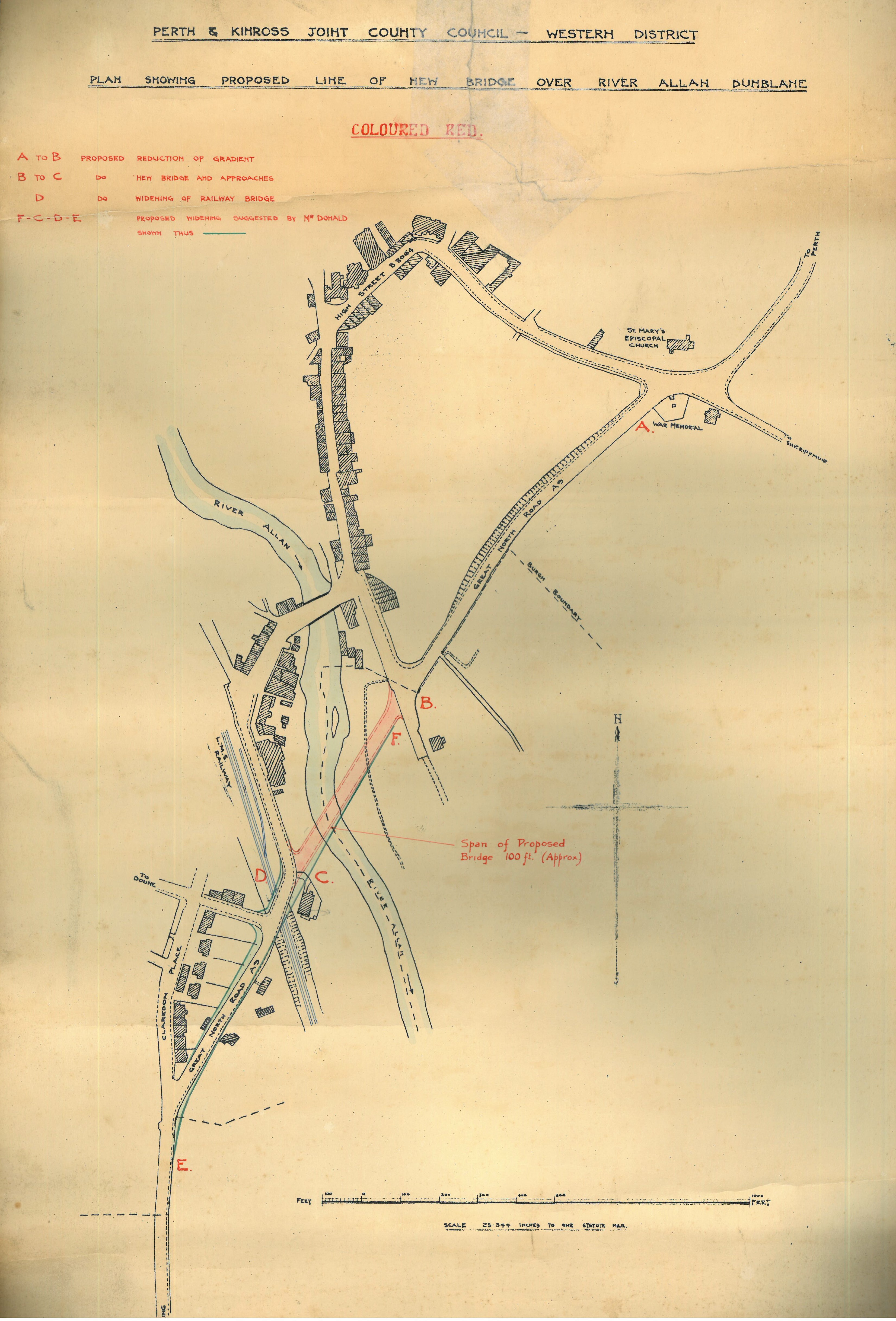
We continue to focus on waterways in the second year of Scottish Coasts and Waters with our Document of the Month for May. This month we are taking a look at the plan showing the proposed new bridge over the River Allan in Dunblane dating from 1935.
The Dunblane town council first proposed the idea for a new bridge over the River Allan to the District Committee in May 1930. Some members of the council suggested widening the High Street road instead but it was eventually unanimously decided to forward the plans of a new bridge to both the District Committee and the Ministry of Transport. The council believed that the new bridge was needed in order to relieve the heavy and dangerous flow of traffic at the corner of the Stirling Arms Hotel, now known as The Riverside. There were several reports of vans being overturned and some of the road accidents even proved fatal. One such accident occurred on 22 Jul 1935.
The process was delayed for many years with dozens of letters being sent back and forth from the town council, county clerk, and Provost to the Ministry of Transport and Roads Committee. Meetings continued to take place over the years, where council members discussed the logistics, lighting, and surrounding land of the proposed new bridge. Eventually, in May 1933, government assistance for the project was granted and some progress was made in terms of getting the project up and running.
In a meeting on 12 Mar 1935, the council agreed to proceed with the new bridge without delay after a number of further road accidents urged the council members to push on. Our Document of the Month shows the plans of the proposed line of the new bridge and was drawn up on 26 Apr 1935 by the road surveyor’s office in Dunblane. The plan shows the proposed new road bridge would extend from the Great North Road (A9) over the River Allan, acting as a second route over the water. The first route over the river being Dunblane Bridge, which links the High Street to the railway station and Bridgend. The original structure was a single-arched bridge made of yellow dressed stone and was built by Bishop Finlay Dermoch in c. 1410. It was widened to the south in 1849 and pavements were added in 1927. The bridge remains in use by local traffic operating a one way system.
Despite the town council’s enthusiasm to push on with the new bridge, there was further delay on the side of the Ministry of Transport. The council even contacted the Duchess of Atholl, the Scottish Unionist Party’s Member of Parliament for Kinross and West Perthshire from 1923 – 1938, in 1937 to ask ‘if something could be done to expedite commencement of the work on this bridge’.
Some progress was made with the drafting and discussion of plans at a meeting on 18 Mar 1937. Here, the council considered the approaching roadway, central reservations, and shrubbery with the estimated cost of the project coming out to £62,900; approximately £3.1 million by today’s standards. The scheme also included the widening of the Dunblane Railway Bridge, the plans for which can be seen in our Document of the Month, and provisions for a new footpath. The erection of the new bridge also meant that the Dunblane slaughterhouse had to be demolished, it was rebuilt at the same location despite objections from the Department of Health that a new abattoir in Dunblane was not necessary due to the low numbers of animals being slaughtered and improvements in motor transport meant that butchers were more than able to travel to Stirling. A new water main was also discussed but was later denied due to the onset of World War II. The town’s war memorial, seen in the bridge plan, also had to be moved to a new location.

After many years of back and forth, construction was finally given the go ahead in 1938 with construction of the bridge overlapping with the beginning of the Second World War, at which point the town council’s discussions quickly turned to air raids and evacuation plans. The bridge is now part of the B8033 Perth Road beginning at Keir Roundabout before ending at the village of Braco, roughly 5 miles north of Dunblane.